


Earth science is more than memorizing rock types or weather terms — it is the study of the dynamic systems that make life on Earth possible. Over the years, while studying and teaching foundational geoscience concepts, I’ve noticed that students understand topics far better when they connect textbook theory to real-world evidence, scientific data, and practical examples.
This guide explores the most important earth science topics every student should master — supported by scientific authorities such as NASA, the United States Geological Survey, the National Oceanic and Atmospheric Administration, and the Intergovernmental Panel on Climate Change.
What Is Earth Science?
Earth science (geoscience) studies the structure, systems, and processes of our planet. It integrates:
- Geology (solid Earth)
- Meteorology (atmosphere & weather)
- Oceanography (oceans)
- Hydrology (water systems)
- Astronomy (Earth in space)
In classroom settings, I’ve found that students grasp the scope of Earth science more clearly when we treat Earth as a connected system — where land, water, air, and life constantly interact.
1. Plate Tectonics and Earth’s Structure
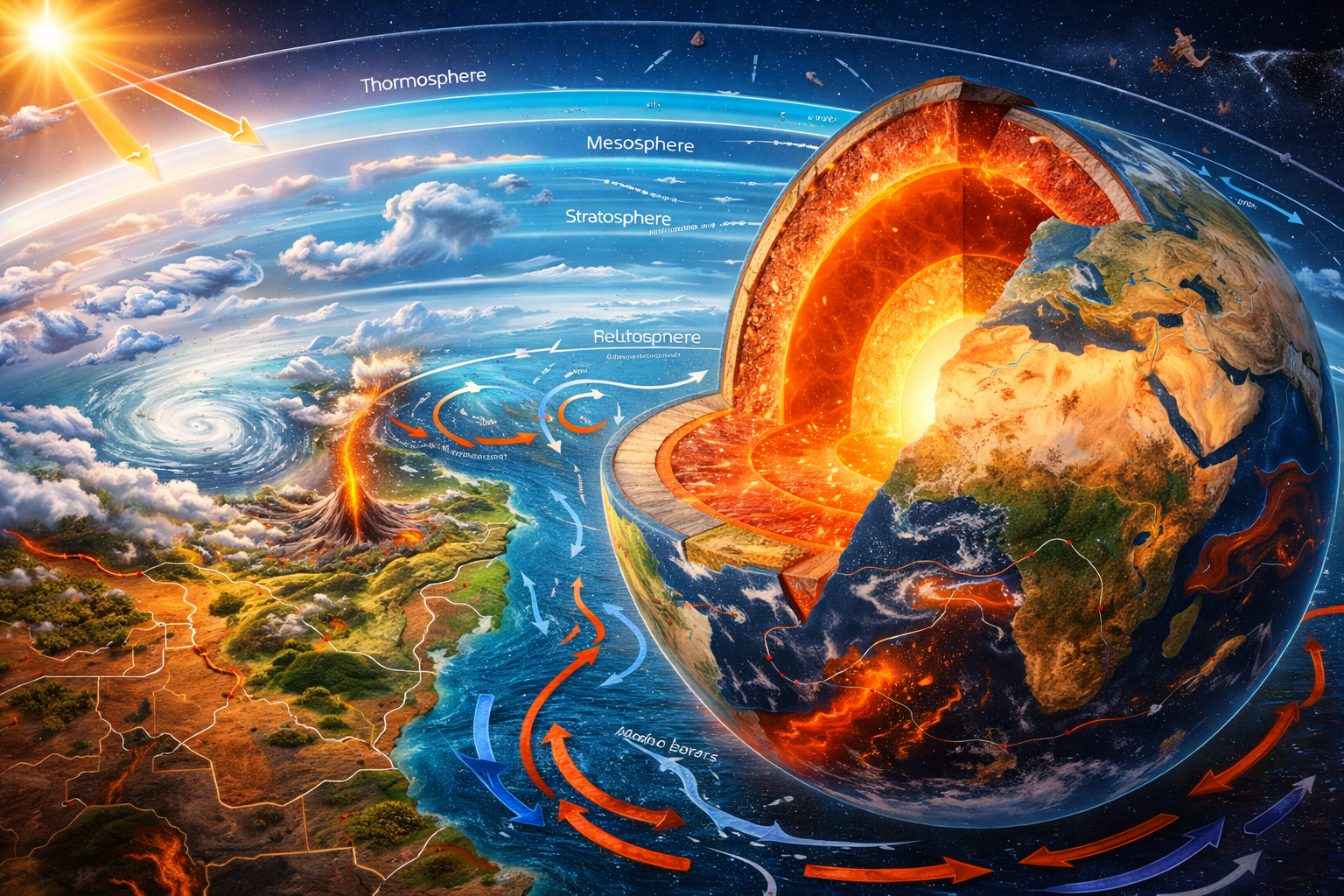
Earth’s Internal Layers (Scientific Detail)
According to the United States Geological Survey, Earth consists of:
- Crust – thin outer layer (5–70 km thick)
- Mantle – ~2,900 km thick, semi-solid
- Outer Core – liquid iron and nickel
- Inner Core – solid iron-nickel alloy
The lithosphere (crust + upper mantle) floats on the semi-fluid asthenosphere. Movement here drives plate tectonics.
Plate Boundaries
There are three main boundary types:
- Convergent – plates collide (e.g., Himalayas formation)
- Divergent – plates move apart (mid-ocean ridges)
- Transform – plates slide past each other (e.g., San Andreas Fault)
When demonstrating this with foam blocks in class to simulate fault stress, students quickly see how pressure accumulates and releases — helping them understand earthquakes physically rather than abstractly.
⚠ Important Clarification:
Scientists cannot predict the exact time of earthquakes, but studying plate boundaries allows identification of high-risk regions (USGS).
2. Rocks and Minerals
The rock cycle explains how Earth materials continuously change form.
Three Rock Types
- Igneous – formed from cooled magma/lava
Example: Granite (slow cooling → large crystals) - Sedimentary – formed from compressed sediments
Example: Sandstone, limestone (often fossil-bearing) - Metamorphic – altered by heat and pressure
Example: Marble (from limestone)
In lab sessions examining granite versus basalt, crystal size differences vividly demonstrate cooling rate effects — a detail students remember better after direct observation.
According to USGS, rock identification plays a major role in construction, mineral exploration, and understanding Earth’s history.
3. Earth’s Atmosphere and Weather
The atmosphere consists of five main layers:
- Troposphere (weather occurs here)
- Stratosphere (contains ozone layer)
- Mesosphere
- Thermosphere
- Exosphere
The ozone layer in the stratosphere absorbs harmful ultraviolet radiation (NASA).
Weather Fundamentals
According to National Oceanic and Atmospheric Administration:
- Wind forms due to pressure differences
- Hurricanes require warm ocean water (≥26.5°C)
- Jet streams influence global weather patterns
When students track real-time hurricane maps from NOAA, they see how ocean temperature, air pressure, and wind shear interact dynamically.
4. Oceans and the Water Cycle
Oceans cover approximately 71% of Earth’s surface (NASA).
They regulate climate through:
- Ocean currents (e.g., thermohaline circulation)
- Heat storage
- Carbon absorption
The Water Cycle
Evaporation → Condensation → Precipitation → Runoff → Infiltration
In practical exercises, tracing local rainfall patterns to nearby rivers helps students understand hydrology beyond diagrams.
Hydrology is critical for:
- Flood management
- Groundwater sustainability
- Agriculture planning
5. Soil and Landforms
Soil forms through weathering of rock over time.
Main soil layers:
- Topsoil (organic-rich)
- Subsoil
- Parent material
Landforms are shaped by:
- Erosion
- Weathering
- Tectonic uplift
Urban planners and farmers rely on soil classification to determine building stability and crop suitability.
6. Natural Resources & Sustainability
Earth provides:
Renewable Resources
- Solar
- Wind
- Hydropower
- Responsibly managed groundwater
Nonrenewable Resources
- Coal
- Oil
- Natural gas
- Minerals
According to the USGS, mineral resource mapping helps governments plan sustainable extraction while minimizing environmental impact.
⚠ Trust Note:
Groundwater is renewable only if recharge rates exceed withdrawal rates.
7. Climate Change and Earth Systems
Climate science is strongly supported by evidence from the Intergovernmental Panel on Climate Change.
Key Findings:
- Global surface temperature has increased approximately 1.1°C since the late 19th century (NASA).
- CO₂ levels now exceed 420 ppm — highest in at least 800,000 years.
- Sea levels are rising due to thermal expansion and melting ice.
How the Greenhouse Effect Works
Greenhouse gases absorb infrared radiation and re-emit it, creating radiative forcing that warms the lower atmosphere.
Students often confuse weather and climate. I emphasize:
- Weather = short-term atmospheric conditions
- Climate = long-term average patterns (30+ years)
Understanding this distinction prevents common misconceptions.
8. Astronomy and Earth’s Place in Space
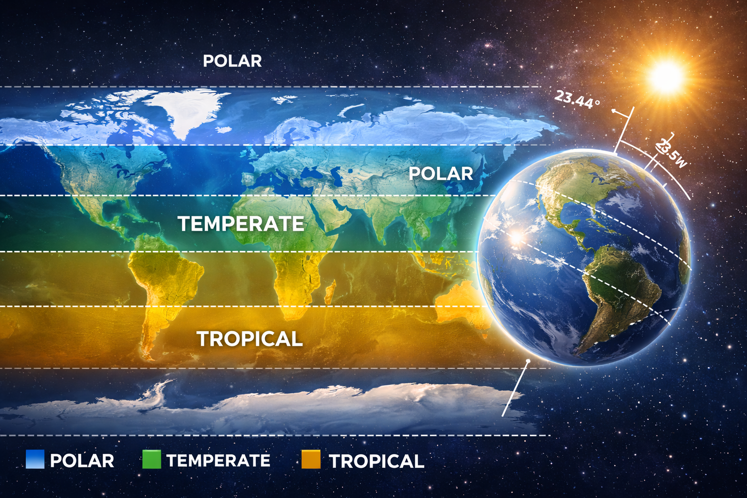
Earth’s rotation causes day and night.
Earth’s axial tilt (23.5°) causes seasons.
Gravitational interactions with the Moon drive tides.
Impact events — such as the asteroid believed to have contributed to dinosaur extinction — show how cosmic forces shape Earth’s biological history.
Observing lunar phases over a month is one of the simplest experiential learning activities that reinforces celestial mechanics.
Study Tips for Students
- Use diagrams when studying plate boundaries.
- Practice identifying rock samples visually.
- Track real-time weather maps via NOAA.
- Review climate graphs from NASA datasets.
- Create flashcards for atmospheric layers.
Conclusion
Earth science is a system-based discipline connecting geology, water, atmosphere, and space. Backed by research from NASA, NOAA, USGS, and the IPCC, these core topics form the foundation every student needs.
A strong understanding of Earth systems equips students not only to pass exams — but to interpret scientific data, understand environmental challenges, and make informed decisions in a changing world.
Earth science is not just academic knowledge — it is literacy about the planet we depend on.