


Earth’s surface is the result of billions of years of geological change. Volcanic eruptions, tectonic plate movement, wind and water erosion, and shifting climates have shaped landscapes that are not only visually striking but scientifically significant. Some of these places are so rare that they exist nowhere else on the planet, offering valuable insight into Earth’s history, climate systems, and biological evolution.
This article examines some of the world’s most unique landscapes and geographical wonders, explaining how they formed, why scientists study them, and what makes each location distinct on a global scale. The information presented here is based on established geological research, environmental studies, and documentation from recognized scientific and cultural institutions.
What Defines a “Unique” Landscape?
In geography and earth science, a landscape is considered unique when it displays characteristics that are rare, scientifically important, or limited in global distribution. These characteristics often include:
- Uncommon geological formations or processes
- Distinct mineral compositions or coloration
- Formation under extreme or highly specific environmental conditions
- Long-term scientific value for studying Earth’s evolution
- Cultural, historical, or ecological significance
Many of these landscapes act as natural archives, preserving evidence of ancient climates, tectonic shifts, and ecological adaptation.
Exceptional Landscapes Around the World
Salar de Uyuni, Bolivia
The World’s Largest Salt Flat
Covering more than 10,000 square kilometers, Salar de Uyuni is the largest salt flat on Earth. It formed after several prehistoric lakes evaporated during the late Pleistocene epoch, leaving behind a thick crust of salt.
Scientific and environmental significance:
- The flat surface is so uniform that it is used by space agencies to calibrate Earth-observing satellites
- Beneath the salt crust lies one of the world’s largest known lithium reserves, a mineral critical for battery technology
- During the rainy season, a thin layer of water creates a mirror effect caused by light reflecting evenly across the salt surface
According to geological surveys, the site provides insight into evaporite formation and mineral concentration in closed basins.
Zhangye Danxia Landform, China
Layered Mountains Formed Over Millions of Years
The Zhangye Danxia landform is known for its multicolored rock layers, created through the deposition of sandstone and minerals followed by tectonic uplift and erosion.
Why scientists study it:
- The vivid bands result from iron and other mineral oxidation over long geological timescales
- The formations date back to the Jurassic and Cretaceous periods
- It provides a visible record of sedimentary layering and continental movement
The site is protected as part of a national geopark due to its geological rarity.
Giant’s Causeway, Northern Ireland
Basalt Columns Shaped by Volcanic Cooling
The Giant’s Causeway consists of approximately 40,000 interlocking basalt columns, most of which are hexagonal. Geological research shows these columns formed when molten lava cooled rapidly about 60 million years ago.
Key scientific value:
- Demonstrates columnar jointing, a well-documented volcanic process
- Offers a clear example used in geology education worldwide
The site is designated a UNESCO World Heritage Site, recognizing its global geological importance.
Antelope Canyon, United States
A Slot Canyon Sculpted by Water
Located in northern Arizona, Antelope Canyon was carved by flash flooding and long-term water erosion within Navajo sandstone.
What makes it distinctive:
- Narrow passageways amplify reflected light, creating shifting color patterns throughout the day
- Smooth, wave-like walls illustrate the erosive power of fast-moving water
- The canyon holds cultural significance for the Navajo Nation, who manage and protect the site
Geologists often reference Antelope Canyon when studying erosion dynamics in arid environments.
Landscapes Shaped by Extreme Environments
Atacama Desert, Chile
Among the Driest Regions on Earth
The Atacama Desert experiences extremely low precipitation due to its location between the Andes Mountains and the Pacific Ocean’s cold currents.
Scientific relevance:
- Some regions receive less than 1 mm of rainfall per year
- Soil chemistry and microbial life are studied by astrobiologists as analogs for Martian environments
- NASA and international research institutions conduct field testing here
Despite its harshness, specialized life forms have adapted to survive in this environment.
Mount Roraima, Venezuela
An Ancient Tepui with Isolated Ecosystems
Mount Roraima is a flat-topped mountain rising above the surrounding rainforest. It is part of the Guiana Shield, one of the oldest geological formations on Earth, dating back nearly two billion years.
Why it matters scientifically:
- Its isolation has led to high levels of endemic plant species
- Steep cliffs limit biological exchange with surrounding areas
- The summit ecosystem evolved independently over millions of years
This makes Mount Roraima important for evolutionary and ecological studies.
Namib Desert, Namibia
An Ancient Coastal Desert
The Namib Desert is considered one of the world’s oldest deserts, with arid conditions dating back at least 55 million years.
Distinctive features:
- Iron-rich sand dunes that reach over 300 meters in height
- Coastal fog provides moisture to plants and animals
- A rare meeting point of desert and ocean ecosystems
The region is frequently studied for climate stability and desert ecology.
Water-Formed Geological Wonders
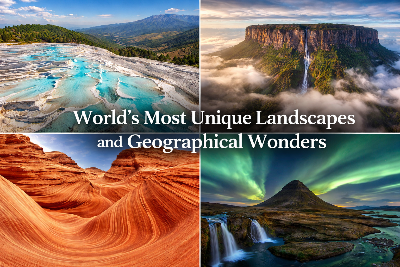
Pamukkale, Turkey
Terraced Pools of Mineral Deposits
Pamukkale’s white terraces formed as calcium-rich thermal waters flowed downhill, depositing travertine as the water cooled.
Why it is significant:
- Demonstrates active mineral deposition processes
- Used for therapeutic bathing since Roman times
- Recognized as a UNESCO World Heritage Site
The site illustrates the interaction between geology and human history.
Plitvice Lakes National Park, Croatia
Naturally Formed Terraced Lakes
Plitvice Lakes consist of interconnected lakes formed by natural barriers created through mineral deposition and biological activity.
Scientific importance:
- Ongoing formation of natural dams provides a rare opportunity to study active landscape evolution
- High biodiversity supported by clear, mineral-rich waters
The park is internationally protected due to its ecological and geological value.
Why These Landscapes Matter
Unique geographical landscapes play a critical role in:
- Scientific research: Studying climate history, erosion, and tectonics
- Environmental education: Demonstrating natural processes in real-world settings
- Cultural preservation: Many sites are deeply connected to local communities
- Conservation awareness: Highlighting fragile ecosystems and the need for protection
They are not only natural attractions but essential resources for understanding Earth’s systems.
Responsible Interaction and Conservation
Increased global interest in these landscapes makes responsible engagement essential. Best practices include:
- Respecting protected-area regulations
- Supporting conservation programs and local communities
- Avoiding activities that damage fragile geological features
- Learning about the cultural and ecological context of each site
Sustainable tourism and education help ensure long-term preservation.
Conclusion
The world’s most unique landscapes are the product of immense time, powerful natural forces, and delicate environmental balance. From ancient deserts and volcanic formations to mineral terraces and sculpted canyons, each location offers valuable insight into Earth’s geological story.
Understanding how these landscapes form—and why they matter—strengthens our appreciation of the planet and underscores the importance of protecting these irreplaceable natural records for future generations.