


Climate determines the crops we grow, the homes we build, and even how we plan our daily lives. But why are regions near the Equator warm year-round while others experience harsh winters and dramatic seasonal shifts?
The answer lies primarily in two measurable and well-studied geographic factors:
- Latitude
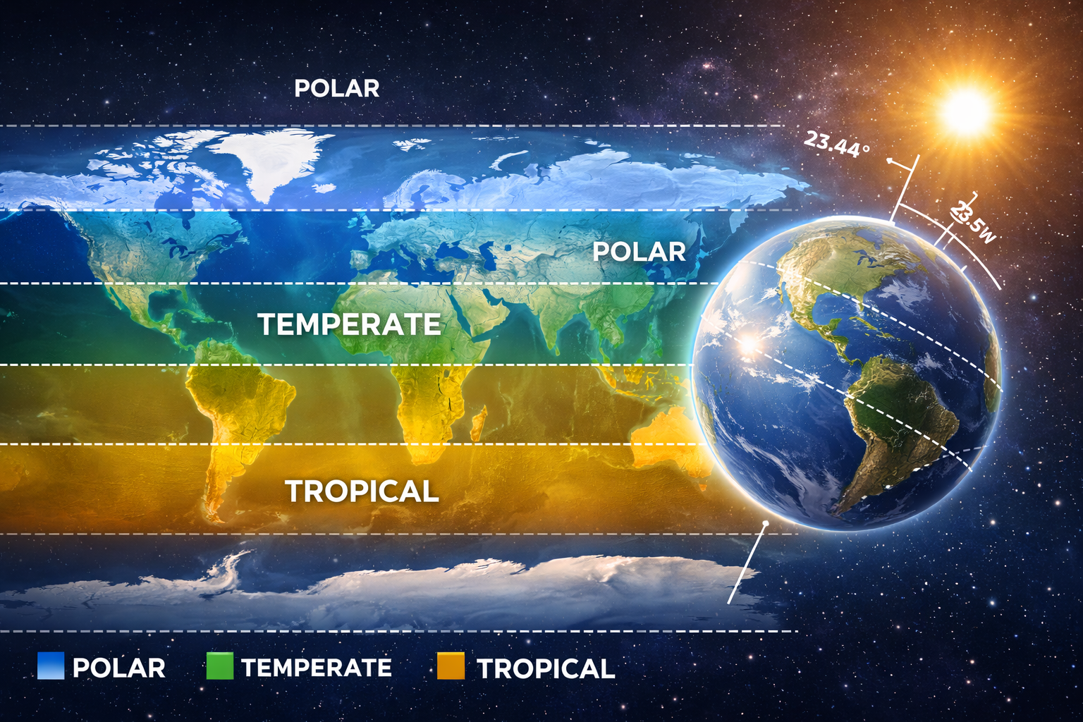
- Earth’s axial tilt (23.44°)
According to NASA and the National Oceanic and Atmospheric Administration, the distribution of solar energy across Earth’s surface — controlled by latitude and axial tilt — is the foundation of global climate patterns.
This article explains:
- What climate zones are
- How latitude determines baseline temperature
- Why Earth’s tilt creates seasons
- How scientists classify climate regions
- Real-world examples that make the science easy to visualize
Climate vs. Weather: A Critical Distinction
Before exploring climate zones, it’s important to clarify a common misconception.
The World Meteorological Organization defines:
- Weather as short-term atmospheric conditions (hours to days)
- Climate as long-term averages measured over at least 30 years
Climate zones describe consistent long-term patterns — not daily fluctuations.
What Are Climate Zones?
Climate zones are large geographic regions that share similar long-term patterns of:
- Temperature
- Precipitation
- Seasonal variation
- Daylight duration
Scientists commonly group Earth into three broad climate zones:
- Tropical
- Temperate
- Polar
More detailed systems — such as the Köppen Climate Classification — refine these categories using temperature and rainfall data.
At the root of all these systems is one key factor: solar insolation (incoming solar radiation).
The Role of Latitude: Why the Sun’s Angle Matters
What Is Latitude?
Latitude measures how far a location is north or south of the Equator:
- Equator: 0°
- Poles: 90° North or South
Latitude determines how directly sunlight strikes Earth’s surface.
Solar Insolation and Energy Concentration
When sunlight hits Earth:
- Near the Equator, sunlight strikes more directly.
- Near the Poles, sunlight arrives at a lower angle.
Direct sunlight concentrates energy on a smaller surface area.
Angled sunlight spreads the same energy over a larger area.
At peak conditions near the Equator, incoming solar radiation can exceed 1,000 watts per square meter, according to NASA measurements. At higher latitudes, that energy is significantly reduced.
This explains why:
- Tropical regions remain warm year-round.
- Polar regions remain cold, even during summer.
A Simple Demonstration (Applied Understanding)
If you shine a flashlight directly onto a table, the light appears bright and concentrated. Tilt the flashlight, and the same light spreads out and appears dimmer.
In classrooms and science demonstrations, this simple experiment effectively models how latitude influences solar intensity.
Earth’s Axial Tilt: Why We Have Seasons
Latitude alone does not create seasons. The second major factor is Earth’s axial tilt.
The 23.44° Tilt
Earth’s rotational axis is tilted approximately 23.44 degrees relative to its orbit around the Sun.
This tilt remains constant as Earth revolves around the Sun each year.
Because of this:
- Different hemispheres receive varying amounts of sunlight throughout the year.
- Day length changes seasonally.
- Solar intensity shifts north and south over time.
How Tilt Creates Summer and Winter
When the Northern Hemisphere tilts toward the Sun:
- Sunlight becomes more direct.
- Days become longer.
- Temperatures rise → Summer
At the same time, the Southern Hemisphere experiences:
- Less direct sunlight
- Shorter days
- Cooler temperatures → Winter
Six months later, the situation reverses.
Without axial tilt, seasonal variation would be greatly reduced — though minor temperature shifts would still occur due to Earth’s slightly elliptical orbit.
The Three Major Climate Zones (With Real-World Examples)
Tropical Zone (Low Latitude)
Location: Between the Tropic of Cancer and Tropic of Capricorn
Solar Pattern: High, direct insolation year-round
Characteristics:
- Warm temperatures year-round
- Small annual temperature range
- Frequent rainfall (in many areas)
Example:
Singapore (1° N latitude) experiences minimal seasonal temperature change and consistent daylight variation.
Temperate Zone (Mid-Latitude)
Location: Between tropical and polar regions
Solar Pattern: Moderate insolation with strong seasonal shifts
Characteristics:
- Four distinct seasons
- Noticeable changes in daylight length
- Moderate precipitation
Example:
London (~51° N latitude) experiences long summer days and short winter days, with pronounced seasonal temperature differences.
Many historically dense population centers developed in temperate zones partly because moderate seasonal variation supported agriculture — though economic, geographic, and historical factors also played major roles.
Polar Zone (High Latitude)
Location: Near the Arctic and Antarctic Circles
Solar Pattern: Low-angle sunlight year-round
Characteristics:
- Very cold temperatures
- Long, dark winters
- Short summers
- Low precipitation (often classified as polar desert)
Example:
Tromsø, Norway (~69° N latitude) experiences polar night in winter and nearly 24-hour daylight in summer.
How Latitude and Tilt Work Together
Latitude sets the baseline solar energy a region receives.
Axial tilt determines how that energy changes across seasons.
Together, they drive:
- Atmospheric circulation cells (Hadley, Ferrel, Polar)
- Trade winds
- Jet streams
- Ocean current patterns
These systems redistribute heat across the planet, shaping global climate behavior.
Additional Climate Influences
While latitude and tilt are primary drivers, regional climate is refined by:
1. Altitude
Air temperature decreases approximately 6.5°C per 1,000 meters (environmental lapse rate).
This is why high mountains near the Equator can remain snow-covered.
2. Distance from Oceans
Water heats and cools more slowly than land, moderating coastal climates.
3. Ocean Currents
Warm and cold currents redistribute heat globally.
4. Wind Patterns
Global circulation systems influence precipitation distribution.
These secondary factors explain why climate zones contain regional variations.
Common Misconceptions About Seasons
“Seasons happen because Earth is closer to the Sun in summer.”
In fact, Earth is slightly closer to the Sun during Northern Hemisphere winter.
Seasons are caused by axial tilt, not distance.
“Climate and weather are the same.”
Weather is short-term. Climate reflects decades of averaged data.
Why Understanding Climate Zones Matters
Understanding climate systems is important for:
- Agriculture planning
- Infrastructure design
- Disaster preparedness
- Environmental policy
- Climate change analysis
Scientific institutions such as NASA and NOAA rely on latitude-based solar distribution models to study long-term climate trends and global warming patterns.
Quick Summary
- Latitude determines how directly sunlight strikes Earth.
- Earth’s 23.44° tilt creates seasonal changes.
- Together, they divide Earth into tropical, temperate, and polar zones.
- Secondary factors refine local climate conditions.
Climate patterns are not random — they are predictable outcomes of Earth’s geometry and orbital mechanics.
Final Thoughts
Climate zones emerge from measurable astronomical and geographic principles. Latitude controls the angle and intensity of incoming solar radiation, while Earth’s axial tilt introduces seasonal variation.
These two forces — supported by atmospheric and oceanic systems — create the structured, predictable climate regions that shape ecosystems, agriculture, and human settlement worldwide.
Understanding these mechanisms provides a foundation for interpreting global climate data and engaging in informed discussions about environmental change.